
Hydrogeological survey to locate groundwater for borewell
1. Introduction
The following Technical Report is prepared by the Company Victor Gonzalez & Assoc SS, summarizes the
obtained results during hydrogeological study for location of the drilling wells sites in the district of San
Carlos del Apa, department of Concepción.
The baseline study, after exhaustive analysis, will be used to achieve uptake groundwater of the Estancia
La Puri.
The work began with the definition of a study in a 17.5 km2
area, and then, start searching for existing
information for study and preliminary conclusion in the Cabinet. Later field work was carried out,
supported by geophysical techniques consisting of vertical electrical soundings (VES) and CT geoelectrics
(TG), aimed at determining the geological structural and hydrogeological point to be subjected to rigorous
analysis that allowed the drawing of conclusions such preliminary work.
The findings of the desk study and clear concepts emerging from the work area will enable the design of
global definitions of the hydrogeological conditions of the study area .
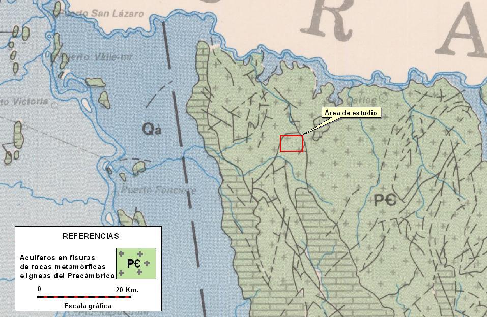
2. Location
Reference hydrogeological study was conducted in the district of San Carlos, department of Concepción.
We can see in the image below, the location of the study area:

The study area is located 21.7 km southwest of the San Carlos del Apa town.
3. Geology and Hydrogeology
The following map shows the location of geological study area in different units and geological formations
present in the eastern region of Paraguay:
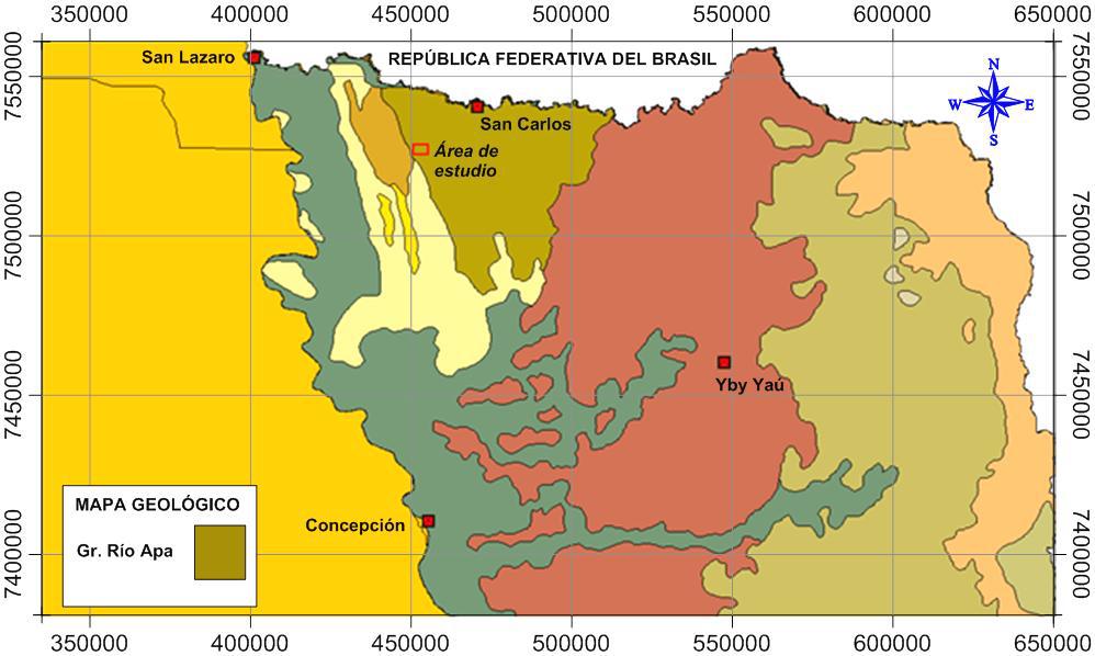
The study area is located in area of occurrence of igneous and metamorphic of Precambrian age of Rio Apa Group. Related to the specific characteristics of geological formations and the aquifer present, this will be described below.
3.1. Rio Apa Group The study area, is seated on a basement, called the Rio Apa Group that corresponds to the lower stratigraphic unit of the geologic column in eastern Paraguay. The reference unit is covered by Itapucumí Group rocks and sediments of Paleozoic age in a discordant. The Rio Apa Group rocks were grouped by Wiens (1986) based on textural criteria into gneissic complex and meta sediments, granites and mafic units and intrusive granites.
3.1.1. Hydrogeological background
In the study area there are few experiences in the search and delivery of groundwater.
The present is the basement aquifer crystalline Precambrian Era aquifer is composed of the same igneous
rocks (granite) and metamorphic rocks - schist, quartzite, gneiss - the same lack of primary porosity,
therefore, are virtually impermeable, however, water can flow through fractured and altered zones. The
flow of the wells are very low and the water quality is generally good, although in the vicinity of major
rivers, may have some degree of mineralization.
4. Cabinet Work
Pre fieldwork of Cabinet studies, consisted observations topographic, satellite images zones fracturing
determination drainage and address flows and entire existing information wells near zone , to determine
the necessary information to be obtained in the field - and hydrogeological observations Vertical Electrical
soundings-.
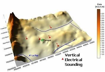
4.1. Geomorphology
The next image, made on the basis of the values obtained from topographic maps, shows the structural
lineaments in the study area.
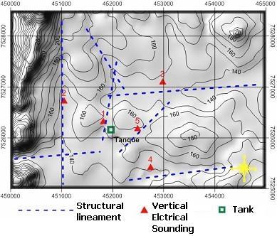
Addresses, preferential, such alignments are: N – S; NNW-SSE; WSW – ENE; NE-SW.
The study area is part of the eastern edge of a morphostructure North - South, made up of limestone
overlying a metamorphic and igneous rocks, bounded on the north by the river Apa, to the south by
Spring Creek , the west by tributaries of the arroyo La Paz and the east by the river Tebicuary. The heights
of the terrain varies, from 130 meters above sea level to 320 m. This area, in the northwest.

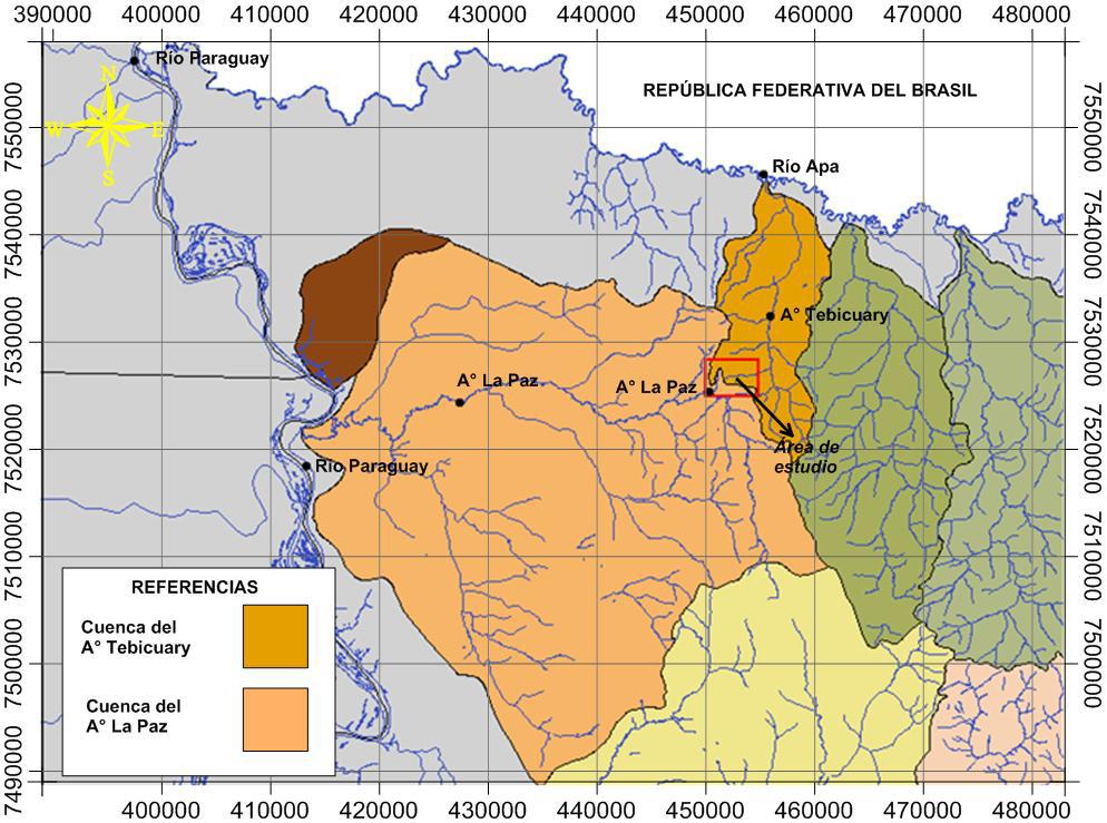
4.2. Hydrology
The study area is divided into two basins, the first, Tebicuary Creek watershed to the north. The stream is
a tributary of the river Tebicuary Apa and this in turn is a tributary of the Paraguay River. The southern
area is the basin of the Arroyo La Paz, a tributary of the Paraguay River.
The map is the distribution of rainfall and potential evapotranspiration, says the study area receives an annual rainfall of around 1295 mm, While the annual evapotranspiration is 1275 mm around, leaving a remnant of 20 mm year, split between runoff and infiltration. The study area is developed metamorphic and igneous rocks of Precambrian age that can form secondary porosity aquifers, aquifers classified as very limited, whose existence depends on the presence of fractures or altered levels of the rocks.

4.3. Analysis of Remote Sensing Images
Due to the complexity of area studies, as ground water obtained, and it be linked exclusively to the
structural conditions, we proceeded to the analysis of remote sensing imagery - GPR - in order to detect
structures of importance in the nearby fields, showing a regional character, close to the study area,
connected to local structures, very important, increasing the possibility of ground water, since these are
sufficient recharge.
The exploratory drilling and geoelectrics CT lines (TG) were located in the vicinity of the apparent fracture.

5. Field Work
The work staff must be complemented with a rigorous job field consisting of: hydro geological
observations techniques and applications geophysical information sources from situ directly, in allowing a
confrontation with the information of Cabinet.
5.1. Hydro geological Observations
He has done a survey of water sources (dug well and spring) in the study area, the following table
presents a summary of the data:
| SourceNo. | Coordinates(UTM) | Type | Prof.(m.) | Water Level (m) | Character | C.E.(μS/cm) | S.T.D (mg/l) | PH | Owner | |
|---|---|---|---|---|---|---|---|---|---|---|
| X | Y | |||||||||
| FT01 | 453628 | 7528252 | dug well | 5.0 | 2.0 | Permanent | 530 | 227 | 7.9 | Est. Buena Vista |
| FT02 | 451955 | 7526053 | dug well | 9.0 | 1.3 | Temporary | 80 | 40 | 8.3 | Est. La Puri |
| FT03 | 450750 | 7527550 | spring | Permanent | Permanent | 45 | 7.2 | Est. La Puri | ||
The source of reference (FT03) is typically used with a flow, measured 600l/h. He himself was subjected
to a trial where they left to flow freely water for a period of 19 hours, until its stabilization at 0.58 meters
(running water in the gap 0.40 meters), the flow is stabilized in the range of 300l/h.
It comes in the following image the distribution of them:

5.2. Applications of Geophysical Techniques
Then proceeded to run a campaign consisting of geophysical vertical electrical soundings (Sevso) and CT
lines geoelectrics (TG). Run five vertical electrical soundings and five lines geoelectrics tomography (TG).
5.2.1. Vertical Electrical Soundings Results
5.2.1.1. Measurement System
State Land: Dry.
Plano Used: Leaves National Charter 5376 II, 5476 III. Scale 1/50.000
Measurement Type: Vertical Electrical Sounding.
Method: Schlumberger.
5.2.1.2. Characteristics of Vertical Electrical Soundings
| SEV No. | Coordinates(UTM) | Sector | Type | AB/2(m) | Energy | |
|---|---|---|---|---|---|---|
| X | Y | |||||
| 1 | 451817 | 7526313 | Potrero Hill Cora | Exploration | 100 | Single phase to 100 m. |
| 2 | 451047 | 7526718 | Potrero Picuiva | Exploration | 100 | Single phase to 950 m. |
| 3 | 452980 | 7527091 | Potrero Tuyuti | Exploration | 100 | Single phase |
| 4 | 452743 | 7525413 | Potrero Campo Via | Exploration | 100 | Single phase |
| 5 | 452488 | 7526175 | Potrero Boqueron | Exploration | 100 | Single phase to 200 m. |
5.2.1.3. Location of Vertical Electrical Soundings

5.2.1.4. Profiles of Vertical Electrical Soundings
STAY THE PURI - SAN CARLOS THE APA
SEV 01. UTM coordinates, X: 0451817, Y: 7526313.
Potrero Sector Cerro Cora, on Section TG01
Electricity: Single phase 1 wire to 100 m.

STAY THE PURI - SAN CARLOS THE APA
SEV 02. UTM coordinates, X: 0451047, Y: 7526718.
Potrero Sector Picuiva on Section TG02
Electricity: Single phase 1 thread to 950 m.

STAY THE PURI - SAN CARLOS THE APA
SEV 03. UTM coordinates, X: 0452980, Y: 7527091.
Potrero Sector Tuyutí on Section TG03
Electricity: Single phase 1 thread.

STAY THE PURI - SAN CARLOS THE APA
SEV 04. UTM coordinates, X: 0452743, Y: 7525413.
Sector Field Potrero Road, on Section TG04
Electricity: Single phase 1 thread

STAY THE PURI - SAN CARLOS THE APA
SEV 05. UTM coordinates, X: 0452488, Y: 7526175.
Potrero Sector Boqueron, on Section TG05
Electricity: Single phase 1 wire to 200 m.

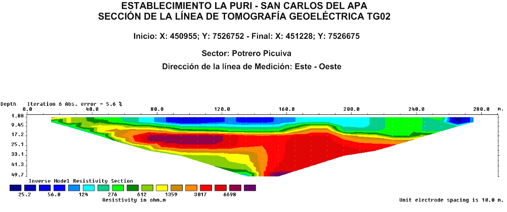
5.2.2. Geoelectrics CT lines (TG)
5.2.2.1. Measurement System
State Land: Dry.
Plano Used: Leaves National Charter 5376 II, 5476 III. Scale 1/50.000
Measurement Type: CT geoelectrics
Disposition Electrodes: Wenner – α
Number of electrodes: 30
Electrode spacing: 10 meters
5.2.2.2. Characteristics of Geoelectrics CT Lines
| Geoelectrics Tomography Line No. | Coordinates(UTM) | Length(m) | Maximum depth of investigation(m) | Sector | |||
|---|---|---|---|---|---|---|---|
| Initiation | Final | ||||||
| X | Y | X | Y | ||||
| TG01 | 451678 | 7526359 | 451947 | 7526273 | 290 | 49.7 | Potrero Cerro Cora |
| TG02 | 450955 | 7526752 | 451228 | 7526675 | 290 | 49.7 | Potrero Picuiva |
| TG03 | 452948 | 7526907 | 452989 | 7527149 | 290 | 49.7 | Potrero Tuyuti |
| TG04 | 452739 | 7525461 | 452768 | 7525177 | 290 | 49.7 | Potrero Campo Via |
| TG05 | 452615 | 7526013 | 452439 | 7526238 | 290 | 49.7 | Potrero Boqueron |
5.2.2.3. Location and Section Geoelectrics CT lines


5.2.3. Interpretation
Vertical Electrical Soundings (SEV)
| Lithology | Resistivity (ohm.m) |
|---|---|
| Residual soil, yellow-whitish, gritty texture, slightly dry, low clay (in SEV 01 and 03). Sequence of metamorphic rocks, crystalline state, arranged in slabs, broken, clean, with opportunities to recharge. Sometimes: resistive dry level, with slightly lower sequence clay, with low resistivity (SEV 02, 04 and 05). Maximum floor length is 3 m. | 160 a 127 266 a 15 |
| Sequence altered fractured crystalline rocks, whitish to yellowish, sandy, unstable possible length and composed of loose rocks and gravel, little clay cementation. Length with the potential for groundwater storage and possible contributions in the SEV 01, 03 and 05. Maximum length of SEV 01 is 37 m. | 115 a 127 |
| Crystalline sequences, formed by metamorphic rocks such as quartzite and gneiss, arranged in slabs, sparsely fractured. Precambrian rocks are massive North Eastern Paraguay. They have reduced potential for groundwater storage, poor hydro geological conditions. | 17.600 a 60.166 |
Geoelectrics CT
| TG No. | Interpretation |
|---|---|
| TG 01 TG 03 TG 04 TG 05 |
Considering the geoelectric section of 290m, side length, there is a sequence undifferentiated, including: resistive soil with values ranging from 52 to 240 ohm.m, in its middle segment, which covers much of the section, with thicknesses of interest until about 30 m. Poor cementing clay and soil washing, basically composed of sandy sediments and altered the top and underlying rocks fractured, which could in certain periods of the year, receiving rainfall recharge groundwater aquifers and shape. TG 01: 30 m TG 03: up to 17 m, 21 m. TG 04: up to 17 m TG 05: 30 m. |
| TG 02 | The area of application of the TG 02 has raised expectations, but the results have not formed. However, a careful analysis of the chart enables us to discern the existence of discontinuities that indicate conditions of the underlying rock mass fracturing, without favorable conditions. It is notorious rock a disaggregated level, sandy, but possibly low power (thick). An intermediate block and fractured crystalline rock basement with large blocks, which is widespread, with projection to the final depth of the section, formed by the same rocks. Fractures in the prevailing levels of 276 specific resistive values ohm.m. |


6. Conclusion
The information obtained through desk study, the vertical electrical soundings (Sevso) and CT geoelectrics
(TG), made field work were processed in previous exposures to try to draw conclusions, as accurately as
possible, hydro geological conditions of the study area, to locate alternative sources and potential
boreholes in favorable areas. They will be used as sources of supply of water supply draft of the Estancia
La Puri District San Carlos del Apa.
Analysis of Cabinet made from water sources used as references to the conclusion that hydrogeological
possibilities:
- In all cases there is a floor covering, usually of a sandy texture, slightly clayey, to a maximum depth of 3.0 m.
- Following a sequence of sediments, formed by rocks fractured and dispersed to sand and gravel, located in situ quartz texture and low clay cementation of favorable conditions for the storage of groundwater, which can form up to 37 m lengths according to TG 01, SEV as 01 or 30 m,.
- In the profile analysis is also distinguished in the basal position, massive crystalline rocks, quartzite, sparsely fractured sequences that can form very favorable for groundwater storage. Lithologically correspond to geological formations of the Precambrian North Eastern Paraguay, with little to no chance hydrogeological.
- Static water levels in the area are on average in the order of 0.0 to 5.0 m.
With respect to the vertical electrical soundings, subsurface geoelectrical response of the area covered by the existence of resistive layers of interest. The resistive values correspond to greater lengths of saturated soil and rock mass by the presence of quartz-type crystalline rocks (metamorphic), generally have higher resistive values between 17,600 to 60,166 ohms. m.
In some cases, at certain levels of resistive are distinguished ohm.m values below 30, it could be a sequence of fractured rocks, clay sequences that must be well evaluated relative hydrogeological interest because of the possibility of store water in the above levels.
Normal values for fractured rocks with certain conditions of saturation, would be around 115 to 127 ohm.m, why are convinced that certain levels of geoelectric column cut would have relatively favorable conditions for the storage of groundwater. Except for the sheets and layers of clay sediments intercalated or low rainfall in the area.
The securities referred to geoelectrical readings correspond almost exclusively to the rocks of Precambrian age geologic units.
Model of crystalline basement profile in relation to permeability.

7. Recommendations
According to the above, and the desire to use the limited options presented by the area, we recommend
two alternative uses of groundwater, the first related to the improvement, recruitment and leadership of
the existing spring water, and the second the construction of tube wells.
ALTERNATIVE No. 1Involves the improvement of the facilities of the spring, provide it with cover.
Conduction of water, by gravity (height difference of 41 meters and a distance of 1846 meters) to
5,000-liter tank semi buried water storage, it must have a control system for automatically closing after
filling the tank. For lifting the reservoir tank semi existing buried, use a centrifugal pump.

ALTERNATIVE No. 2
Drilling of tube wells in the following points:
Site No. 1 - Located in the area where the survey was carried SEV01 in the area of Potrero Hill Cora, 215
m northwest of the tank, coordinates (UTM) X: 451917, Y: 7526313.
Site No. 2 - Located in the area where the survey was performed SEV05 in the area of Potrero Boqueron,
520 meters east-northeast of the tank, coordinates (UTM) X: 452488, Y: 7526175.
The wells, with estimated depth of 35 meters depth, must be drilled in the percussion system cable. The aim is the withdrawal of water, if any, sediment levels, and altered fractured rock. The diameter of the hole should be 6 ½ inches.
In addition to sampling the outgoing material well and advance registration is recommended drilling hole geophysical logging (resistivity, spontaneous potential and natural gamma) to determine production sites or unstable material on the walls of the well. It is essential the presence of the resident geologist who, according to information obtained during drilling (including the flow rate obtained at different levels), which would join geophysical logging data, decide upon termination. Total tubing with filters in optimal sites with PVC jacket of 116 mm. Cleaning and development, test pumping, disinfection and sampling for physical analysis, chemical and bacteriological.
The well must be constructed according to current legislation (Rules SEAM).
Anticipating a sanitary seal at least 5 meters.
We recommend a protective perimeter of the pit (Pit Operational Area) of 20 m radius. The same should
be under control of the body carrying out the use of the source.
In the reference area should not be permitted activities not related to the extraction of water itself and yet they must be evaluated and closely monitored to prevent pollutants from reaching the source either directly or through ground disturbance adjacencies. The portions of the land being used for maintenance of the well must have a concrete floor. To prevent invasion of animals or vandalism should put a perimeter fence.
7.1. Location Map of Sites for Drilling Wells

7.2. Tentative Design of Tubewells

8. Photographs


Views of the Spring


9. References
- Strong, A. (1984). Survey Study geoelectrics direct current applied to hydrogeology in Itacurubí del Rosario. Department of San Pedro. Republic of Paraguay.
- Orué, D. thesis. 1997.
- 83/005 PAR Project, Geological Map of Paraguay, 1986.
- Project PAR 83/005, Hydrogeological Map of Paraguay, 1986
- OEM, License No. 00045-450-935-023
- Office XP Pro W / Publisher 2002, License No. 00035-934-351-916
- Dynamic Probing, Number of Licensed use 6D91EFD59A59553064 Control - Customer No. 2241.
- Geothecnic No. 5773959F5053430592 Control, Licensed use - Customer No. 2241
- Golden Surfer 9 - Use under Licence.
- Stratigrafer V6, No. 270D676D615317D76 Control, Licensed use - Customer No. 2241
- IPI2WIN, Resistivity Sounding Interpretation Version 3.0 3a, used under license
- Olmo Alarcón, M. López Geta, J.A. - News of the geophysical techniques applied to hydrogeology - Madrid, Spain - 2000.