
Use of Magneto Telluric Survey as a Tool for Ground Water Potential Assessment in Hard Rock Areas, Irunjalakuda, Thrissur District, Kerala
Sivakumar. A, Mohamed Abdul Kadar Prabhu H and B. Gowtham
Department of Geology, Presidency College (Autonomous), Chennai.
Abstract:
The present research article documents
the effectiveness of Magneto Telluric survey in
Targeting potential aquifers in hard rock terrains.
Geophysical survey methods like Electrical
Resistivity Survey and Magneto Telluric Survey are
often used for detection of potential aquifers in
Hard rock terrain. However, due to lateral space
constraints electrical resistivity survey is not often
impossible to conduct in cities and hilly terrains.
Magneto telluric (MT) is an electromagnetic
geophysical method for inferring the Earth's
subsurface electrical conductivity from
measurements of natural geomagnetic and geoelectric
field variation. Magneto Telluric Survey
requires lateral space of 20 to 25 m to explore the
sub surface at any location. Magneto Telluric
survey was conducted at 4 locations in south north
orientation at Annalur village near Irinjalakuda,
Thrissur District, Kerala State. The site falls in hard
rock granitic terrain. Out of the 4 locations where
MT was conducted, one location showed a
promising groundwater potential and
recommended for drilling. Location 3 was
recommended for drilling and the bore well
wasdrilled to the depth of 180 meters (600 feet)
below ground surface. Three groundwater
promising zones were identified as per the MT
survey data. The well recorded a yield of around
12000 litres per hour and the core samples well
correlated with the MT survey data. Magneto
Telluric method may be used by hydrogeologists
for identification of potential aquifers.
Keywords: Magneto Telluric Survey, Aquifer,
weathered rock, hard rock, borewell and
groundwater potential.
Introduction:
Hydrogeologists all over the world
use the data of geological, hydrogeological and
geophysical surveys to identify and delineate
potential aquifers. In most cases geophysical
surveys was used for ground water targeting was
done for industries, residential apartments and
agricultural landscapes. Over the last decades,
there has been great advancement in the
application of geophysical tools in groundwater
exploration.
Magneto Telluric survey technique is the
latest State-of-the-art available to locate potential
borewell locations in areas where there are limited
lateral space. In hard rock areas groundwater
potential lies in weathered rock and fractured rock
presence. Historically and even nowadays
Electrical Resistivity surveys are used. The greatest
limitation of 1D resistivity sounding method is that
it requires lateral space. For 1 D Electrical
Resistivity surveys lateral space twice the depth of
the investigation is required. For conducting a
Typical 1-D resistivity sounding to 100m depth, a
lateral distance of 200m is required.
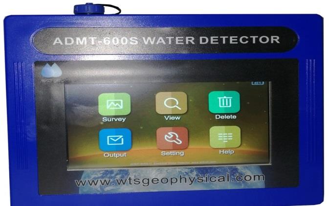
Electric Field Geophysical Prospecting
Instrument, referred to as the 2D Audio magneto
telluric water detector (ADMT-800S) in this article,
and was used for electromagnetic propagation.
ADMT 800 S is a portable equipment and works by
measuring the electric field component of the
earth’s magnetic field in different and can easily
demarcate the potential points of aquifers. ADMT
800 S is an effective tool to provide a geolectric
overview of the subsurface sequence of a
particular area of interest In many terrains lateral
space is not available for conducting Electrical
Resistivity Surveys. In such terrains. Magneto
Telluric Survey is very useful to scan and identify
potential groundwater locations especially in hard
rock terrain. Few research articles have
documented the effectiveness of using Magneto
Telluric Survey as an effective tool to determine
Aquifer potential.
Geophysical investigation of groundwater
potential in Iwo, Osun State, Southwestern Nigeria
using audiomagnetotelluric method Etido Nsukhoridem Bassey a,*, Olumide Oyewale Ajani
a, AbdulGaniyu Isah b, Adetunji Ayokunnu Adeniji
a a Department of Physics, Bowen University, PMB
284, Iwo, Osun State, Nigeria b Department of
Geological Technology, Federal Polytechnic Ede,
PMB 231, Ede, Osun State, Nigeria, 2023 The
above research outlines the significance of
groundwater for human activities and the
challenges of prospecting in complex basement
terrain. The study suggests using the Audio
magnetotelluric (AMT) method to explore the
subsurface conductivity structure as an indicator
of potential groundwater resources. The research
demonstrates the effectiveness of AMT in mapping
groundwater and characterizing geological
materials up to a depth of 200 m. The analysis
identifies distinct layers with varying resistivity
values, primarily composed of Pegmatite and
Migmatite gneiss. Pegmatite, with its lower
resistivity, acts as a water-bearing zone when
weathered, while Migmatite gneiss’s higher
resistivity suggests reliance on fracture zones
within the bedrock for groundwater exploration.
Shallow potential groundwater zones are
identified at 10–30 m depth in certain profiles,
while deeper zones are detected at 40 m and
beyond across the study area. The prevailing
aquifer systems are influenced by fractures and
weathered zones. The saprock region, located
between fresh bedrock and regolith at 40 m depth
and above, is deemed most promising for drilling
purposes.. The research concludes that combining
the AMT method with ADMT software provides
valuable tools for groundwater prospecting in
complex basement terrain, offering detailed data
on the subsurface resistivity structure and
facilitating the identification of potential
groundwater resources.
The above research article documents
successful delineation of aquifers in granitic
terrain. An Integrated geophysical approach i.e
magnetic impedance(lps1200) and Audio magneto
telluric(ADMT 300s) survey was carried out in hard
rock area of Pathalapattai village, Thiruverambur
Block in Tiruchirappalli District of Tamil Nadu
State, India, for delineation of groundwaterbearing
zones that would be feasible for drilling
deep bore wells for tapping good quantum of
water. The entire area (1 acre of land) was
surveyed and only two places was the favorable
where the magnetic impedance difference was
encouraging. Those anomalous areas were
scanned by 2D Audio magneto telluric scanner up
to the depth of 300m. The technique has provided
information on the subsurface lithology &
structures up to 300 m depth. The study shows
that the groundwater occurrence in the area is
confined to fractured and weathered zones. One
of the location was recommended to drill a bore
well. Comparing and correlating these results with
the drilling data, it is found to be good. It can be
concluded that the established interpretation of
2D Audio Magneto Telluric data and LPS 1200 data
pretty well correlates with the actual fracture
depth and lithological conditions. Thus, the
method not only aids in locating water aquifers
but also helps to avoid bore hole failures.
The research article documents the
Magento Telluric Technique can be effectively
used for mapping potential groundwater locations,
ADMT-600S-X was used and set to transmit signal
into ground for the depth of 300 m for each and a
horizontal distance on the ground to 100 m. In this
regard electric current is sent into the ground to
investigate the subsurface. The result of each
profile are presented in 2D inversions which makes
it easy to interpret in terms of electrical
distribution and variation within the subsurface.
Total of 20 profiles of Magneto – telluric data were
investigated in Adamawa State University Tsahuda
Road Campus and environs. This geophysical
method is basically used in basement terrain which
makes it easy and quickly delineate areas for
groundwater exploration. The results obtained
shows potential profiles for Borehole drilling. This
means that the study area has good groundwater
potentials since majority of the profile gives a
positive results. However, the potentials points
shows that the depths to be drilled varies from 140
m to 200 m depending on the profile.
The article documents delineation of the
borehole aquifer and the potential of the aquifer
with the Audio Magnetotelluric (ADMT)method.
The research was conducted on six measurement trajectories. The result obtained is that in all six
trajectories there is a layer of rocks. These rocks
are thought to come from the eruption of Mount
Batur Purba. The study conludes that in the
research site, the potential and distribution of
water is more in the western area, while in the
eastern area there is less.
Magneto Telluric survey can solve many
hydrogeological problems, including (1) detection
of potential ground water zones or determination
of conductive weathered rock and hard rock
zones); The objective is to map and understand
the resistivity of formations at shallow and deeper
depths belonging to Hard rock formations and
interpret presence of aquifer for locating borewell.
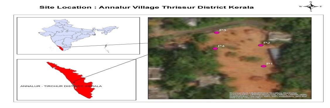
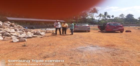
Study Area:
The application of Magneto Telluric
survey was conducted at Annalur Area near
Irinjalakuda in Trichur district . The study area is a
one acre and is a dairy farm. The farm had tried
few poor yielding borewells and was not able to
meet its daily requirements. Earlier ground water
surveys were not successful in the area. The study
location is shown in Fig. 1
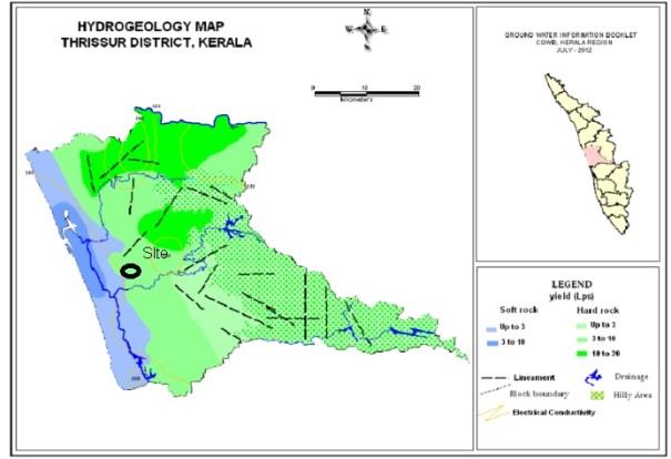
Regional Geology and Hydrology:
Thrissur district is principally made up of hard rocks and sedimentary
formations. Hardrock is made of greanites and gneisses. The geology of Thrissur District is such that it can be
divided into two parts; the western coastal region comprising of loose unconsolidated sediments that have
been deposited on the shore by rivers and ocean currents and the eastern region, which is underlain by hard,
crystalline basement rocks such as gneiss and charnockite. Except for a thin coastal strip of 10-15 km, the
major area of Thrissur district is composed of ancient crystalline rocks. The charnockites and gneisses have a
characteristic ‘foliated structure’ imparted by the dark coloured tabular and flaky minerals. Cutting across
these older rocks are linear bodies called dykes, which are doleritic and gabbroic in nature. The hard rocks
terrains such as granites are usually devoid of primary porosity. Secondary porosity was developed due to
weathering and fracturing of the hard rock and forms a good aquifer zone for groundwater occurrence and
movement. In Annalur the geology consists of granite and gneissic rock.
Geology Map of the Area is shown in Fig 2
Methodology:
Magneto telluric (MT) is an electromagnetic geophysical method for inferring the earth's
subsurface electrical conductivity from measurements of natural geomagnetic and geo-electric field variation.
ADMT equipment was used for the survey.
Magnetic fields in the frequency range of 1 Hz to approximately 20 kHz are part of the audio magneto
telluric (AMT) range.
Depth of investigation depends on the transmitted frequency and resistivity of the subsurface. Lower
the frequency, greater the depth of penetration. The prospecting technique is based on natural electrical field
which is influenced by resistivity contrast of underground minerals and ground water. Without heavy power
supply, it uses low frequency signals & natural electric field as signal source. Equipment is automatically
controlled by micro PC with a high resolution of measuring accuracy of 0.001 mill volt. The output will be in the
form of 2 D profile with anomalous zones & in conjunction with geological & hydro geological conditions,
recommendations were provided. Currently this is one of the most updated and effective detecting method in
the world. It can be widely used for detail and general survey of underground water detecting, geothermal and
other energy prospecting work. It improves the successful rate of drilling water well.
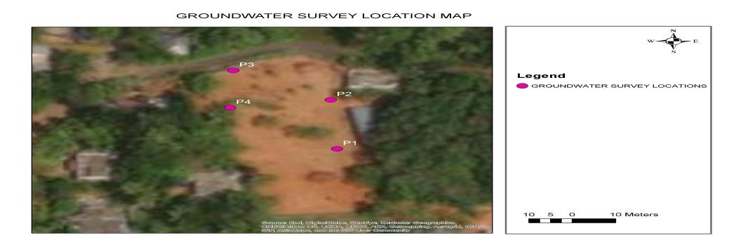
For Magneto Telluric method the survey data outputs were generated in the form of contour
sections. The low resistivity zones and high resistivity zones were demarcated using contrasting thematic
colour. The water bearing zones were shown in blue color and light violet colour. Traverse with more fractures
zone are ideal locations for targeting ground water. The fractured zones are shown in blue color and location
having more blue zoning are selected for drilling borewell. Magneto Telluric Survey Method was conducted at
4 locations and is shown in Fig. 3.
The magneto Telluric instrument has two electrodes(MN) which are grounded in the target area.
The Magneto Telluric instrument with M and N electrodes into ground the survey is conducted along
straight lines. When the point sampling finished, move the M and N in a certain distance and the same
direction to measure the second point. By this analogy, work until completely measuring the profile. ADMT-
800S penetration depth is around 800 m; when the resistivity fixed, the lower the frequency, the deeper the
penetration depth.
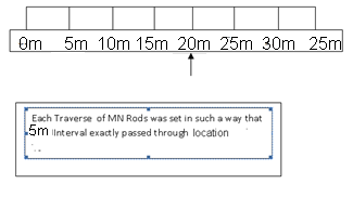
Readings were carried out at 5m interval starting from Station 0 to Station 40m. In site the second
station 20m was chosen to exactly pass through the investigation location. The station details are shown in Fig.
4
Interpretation of Survey Data :
Magneto Telluric survey data is computed through a software and sections
are produced for each traverse which are intrepreted.
This equipment is capable of running self-checks for connectivity of electrodes and generates
warnings on bad contacts. Bad contacts were resolved by pouring water on the ground and then electrode
where driven subsequently to reduce grounding resistance,. Normally a constant spacing between adjacent
electrodes is used.
The Magneto Telluric Instrument is shown In Fig. 5
Reference :
Application of magnetotelluric (MT) study for the identification of shallow and deep aquifers in Dholera
geothermal region Kriti Yadav a, Manan Shah b, Anirbid Sircar c Groundwater for Sustainable Development
Volume 11, October 2020, 100472.
Results and Discussions :
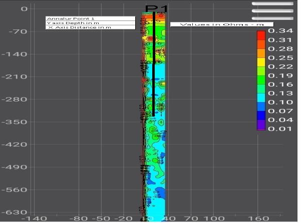
- Magneto Telluric Survey Results.
- Location P1 642155E , 1136659 N.
- At Location 1 following Groundwater accumulations were inferred.
- Three minor zones with moderate resistivity were interpreted to contain minor moisture and fractures.
- Zone 1 10 to 20m depth Minor zone.
- Zone 2 150 to 160m depth Minor zone.
- Zone 3 200 to 210m depth Minor zone.
- Very low resistivity is not observed at this location.
- Location not selected as poor yield is expected.
- Magneto Telluric output of P1 is shown in Figure 6.
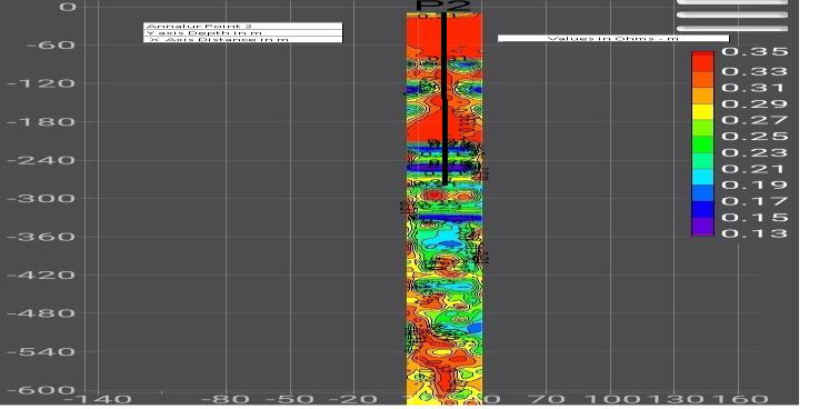
- Magneto Telluric Survey Results.
- Location P2 642171 E, 1136656 N.
- At Location 2 following Groundwater accumulations were inferred Low resistivity zones with 3 minor and 1 potential fracture zones were interpreted at this location.
- Zone 1 10 to 20m depth Minor zone.
- Zone 2 120 to 130m depth Minor zone.
- Zone 3 220 to 230m depth Minor zone.
- Zone 4 250 to 260m depth Major Zone.
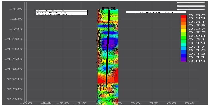
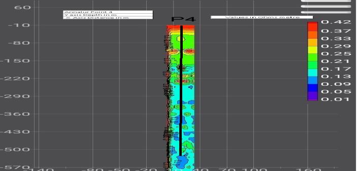
Magneto Telluric Survey Results at Location 3.
Location 3 642174 E, 1136691 N.
At Location 3 Very low resistivity values and maximum groundwater layer accumulations were
inferred Five saturated zones were interpreted to contain moisture and fractures. Location 3 exhibited lowest
resistivity values, maximum groundwater accumulation and also had better groundwater recharge conditions.
- Zone 1 10 to 20m depth Minor zone.
- Zone 2 50 to 60m depth Minor zone.
- Zone 3 80 to 90m depth Minor zone.
- Zone 4 100 to 120m depth Major zone.
- Zone 5 190 to 200m depth Minor Zone.
Location 3 Recommended for Drilling as priority 1
Magneto Telluric Survey Results at Location 4.
Location 4 642157 E, 1136675 N.
At Location 4 Moderate resistivity and very poor ground water accumulations were inferred.
There were no indications of any ground water accumulation or low resistive zones and fractures.
Conclusions:
The site falls under hard granitic gneiss terrain and red Lateritic soil masks the site.
Four points were studied using Magneto Telluric Survey. Based on the survey it is interpreted that the
northern portion exhibits better ground water potential and accumulations than the southern portion of the
site.
Of the Four points validated by Magneto Telluric method Point 3 exhibits promising saturated
fractures at depths and was recommended for drilling boreholes to 200m.
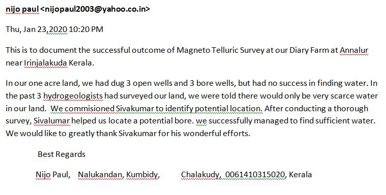
Drilling Results :
Drilling was conducted immediately at Location 3 gave a high yield of around 12000 litres per
hour. Good yield was observed between 100 to 120 m depth as inferred from Magneto Telluric results. The
letter from the owner of the Farm is shown below
Conflict of Interest :
The authors declare no conflict of interest.
Declaration on Funding:
The authors declare that no funding was received for conducting the study and
preparation of the research article.
Acknowledgments:
The authors acknowledge the
Department of Geology, Presidency College,
Chennai – 600 008, India for providing facilities
and support. Incisive comments from the
anonymous reviewers to upgrade the quality of
the paper are thankfully acknowledged.
Data Availability Statement :
The section contour
outputs are provided in the article.
References:
* Geophysical investigation of groundwater
potential in Iwo, Osun State, Southwestern
Nigeria using audiomagnetotelluric method
Etido Nsukhoridem Bassey a,*, Olumide
Oyewale Ajani a, AbdulGaniyu Isah b, Adetunji
Ayokunnu Adeniji a a Department of Physics,
Bowen University, PMB 284, Iwo, Osun State,
Nigeria b Department of Geological
Technology, Federal Polytechnic Ede, PMB
231, Ede, Osun State, Nigeria, 2023.
*
Delineation of Ground Water Potential Site by
Integrated Geophysical Investigations: A Case
Study S. Sundaramoorthy1, Dr. N. Jawahar
Raj2, Dr. S. Selva Raj3, R. Karpagambal4 M.
Kavinraj5.
*
1Research Scholar 2& 3Associate Prof 4 & 5
M.Sc., Student Department of Geology
National College Bharathidasan University
Tiruchirappalli Tamilnadu November 2022.
*
Groundwater exploration using Advance
Magneto Telluric (ADMT-600S-X) in Tsahuda
Road Campus Adamawa state University
Mubi, Adamawa State S. Kasidi Adamawa
State University, Department of Geology
Kasidisimon2002@yahoo.co.uk (Received in
March 2022; Accepted in May 2022) Revealing
Aquifer Potential With Audio
Magnetotelluric(ADMT)Method: Case Study At
Bangli Bali Narcotics Correctional Centre I
Nengah SimpenEarth Physics Laboratory,
Physics Department, Matematics and Science
Faculty, Udayana University Jl. Raya Kampus
UNUD, Bukit Jimbaran, Kuta Selatan, Badung,
Bali, Indonesia, 8036, 2023.
*
Application of magnetotelluric (MT) study for
the identification of shallow and deep aquifers
in Dholera geothermal region by
Kriti Yadav a, Manan Shah b, Anirbid Sircar c
Groundwater for Sustainable Development
Volume11, October 2020, 100472.
*
K.K. Abdul Azeez et al. Magnetotelluric
imaging across the tectonic structures in the
eastern segment of the Central Indian
Tectonic Zone: Preserved imprints of
polyphase tectonics and evidence for suture
status of the Tan Shear.Precambr. Res. (2017).
*
K. Bahr Geological noise in magnetotelluric
data: a classification of distortion types, Phys.
Earth Planet.In.(1991)
*
J.E. Everett et al., Magneto-telluric
investigations in south-western Australia,
Phys. Earth Planet.In. (1967).